
Jig-Map
Jigsaw puzzles came about in the mid-late 18th Century, many of the earliest examples were maps mounted on to wood before being line-cut, or dissected around sea borders and county boundaries etc.
Waddington's continued this trend right into modern times with this excellent set of shaped cardboard puzzles, produced from the early 1960's until the mid 1990's and complete with name quiz pieces to further enhance their educational qualities.
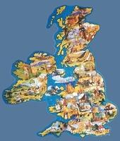
I remember well the Great Britain example, which back in the 1960/70's was a much used puzzle, with a lot of my current knowledge of our coastal shape and county placements emanating from its assembly.
Time spent on others in the set has certainly further enhanced my World Geographic awareness and interest.
As with other sets within the Waddington's portfolio, there is some erraticism in the coding/numbering. With Jig-Maps the same puzzles were often re-issued with different name quizzes and given different numbers. Illustrations have therefore been presented in order of title with a list of relevant stock numbers in the text.
Around 1980 the design was revamped into a smaller range of titles packed in more colourful boxes but with no place name quizzes. The puzzles had larger borders. For more clarity these have been listed after the "main" range sold in the 1960's and 70's.
Many thanks to Steve Woolmer for taking on the challenge of assembling the puzzles in this series and supplying details and photographs as he completes them.




© 2008-2025 David Shearer
Album info
Album Tree
Random image
